Days 1-5 Knighton to Machynlleth 6-10 September 2021
All images for this section are on:
Introduction
It has been over year since the last Trail I completed: the Wessex Ridgeway in March 2020. The final day Steve, Mike and I walked to Marlborough in Wiltshire was just a week before the National lockdown due to the coronavirus pandemic.
I did not write a blog for that Trail, partly because it was completed as a series of day walks; partly due to time pressure of running a cafe and work on the house we moved into in 2018. My last blog was the Coast to Coast , walked in May 2018 and May 2019.
Now I commence my 7th National Trail (and 10th altogether). Glyndwr Way is apparently one of the least walked National Trails, perhaps because it is relatively remote.
We are 5: Mike, Steve, Dom, and Jackie and me. Very much looking forward to it. We are well equipped; the weather forecast is excellent. We have booked accommodation and transfers with Celtic Trails, as it seemed too difficult to work out routes, transfers, and accommodation ourselves in this remote par of Wales. We should have walked this first part in May 2020, but Covid restrictions put paid to that and decided to leave until now, by which time we predicted that restrictions would be lifted.
Day 1 Knighton to Felindre 14 miles
We stay in the George & Dragon; can’t say it is 5* but adequate for our needs. After breakfast we don’t have to prepare bags as we return this afternoon. The route is very indirect to Felindre so we end the day only about 8 miles from Knighton, easy enough for Celtic Trails to arrange a taxi return us to Knighton.
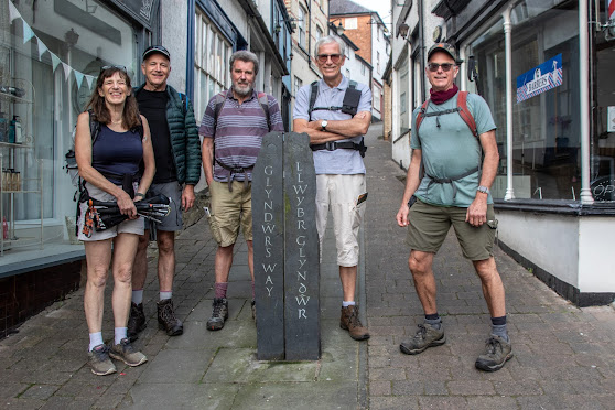 |
| Start point at Knighton |
After the statutory photo by the start point in the Narrows, we head uphill. The maps are not helpful to find the route out of the town, but the route is well waymarked and we use the Cicerone Guide as backup.
After descending some narrow paths, the route is alongside a tributary of the River Teme. A steep ascent on a minor road leads to a track that opens onto farmland with fine vistas in all directions. The going is good; waymarking excellent, and weather unbelievable.
.CR2)
We descend into Llangunllo, a small village with a pub but no other facilities. We rest for a while in the village hall grounds and I discover that I have lost a hearing aid when placing a sweatband on my head.
The Trail leaves the village on a road that passes underneath the railway line that serves the area. It is difficult to believe that many people frequent Llangullo station especially as it is a mile from the village, but great that a line of communication remains.
The Trail coincides with the Heart of Wales Line Trail as it climbs onto Beacon Hill, a 1889 hectare Crown Estates owned area of heathland that is run by Radnorshire Wildlife Trust. The remainder of today’s walk is through the bracken and heather along very well maintained paths passing by Stanky Hill and Black Mountain. We see only two other people; both as we are having lunch. Turns out they are also walking Glyndwr’s Way but seemingly in smaller chunks.
.jpg)
As we near the end of the day, Mike staggers and needs to be helped. We end up with Jackie and Dom heading to meet the taxi while Steve, Mike and I wait for a pick up a mile or so from Felindre at Cefn Pawl. A local woman helps us out by giving us a lift to Beguildy, where we meet the taxi for short journey to Knighton.
This is a stunning walk mostly over grazing land. We get the sense of the remoteness as see virtually no-one and very few habitations. The views are lovely, the going easy.

Day 2 Felindre to Abbeycwmhir 16.5 miles
A relaxed start to the day as we cannot be collected and taken to the start of the route until 0900. Mike is not walking today; good decision give his weakness yesterday. Seems fine this morning but another gruelling day in the heat - it is forecast to be warmer even than yesterday - is not advisable.
So it is 0930 when we start from where we stopped yesterday with Mike: Pen Cawl, about a mile from Felindre. The mileage for both days has been adjusted.
It is a steep descent to Felindre, where we start the ‘proper’ walk for the day at 1000. A short walk through the village leads to a permissive path through a farm and thereafter a steady ascent to an indistinct peak.
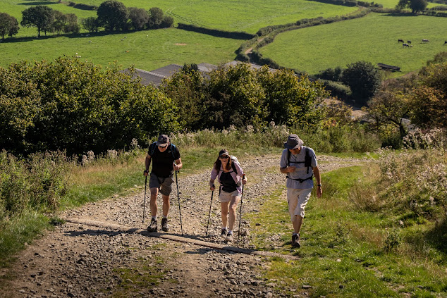 |
| A long ascent on a second very warm day |
The Trail continues through upland farmland with fine views in all directions. The path becomes a track, then a road before a sharp left and descent to a stream, and a further ascent to Fron Top, whence a road leads down to Lanbadarn Fynydd.
A short walk along the A483 leads to a junction where the Trail almost doubles back on itself, along a minor road that rises steeply. We stop for lunch.
Post lunch, continue ascent to the closest point to a wind farm that we have been tracking since yesterday. The Trail goes north, then south again skirting the wind farm that consequently is in sight for much of yesterday and today.
 |
| We see the wind farm from all directions |
A gradual ascent leads to moorland at Moel Dod. It is very warm now and I drink all of my 3.5 litres of fluid during the day, mostly in the hot afternoon. The views are again breathtaking. A descent to the hamlet of Tanypant is followed by the final ascent to the bracken of Ysgwd-fordd.
Last chance to soak in the views before a very steep and well waymarked descent to a minor road that seems to lead nowhere from nowhere alongside Bachell Brook. Unsurprisingly,, no traffic is seen on the mile or so of the Trail. We complete the long day into Abbey cwmhir, arriving at 1745 tired but inspired by the beautiful scenery encountered today. It is a 9/10 day.

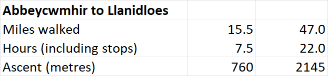
Day 3 Abbeycwmhir to Llanidloes 15.5 miles
We start without Mike again. Shame he is not feeling up to it but better not to risk falling ill; this is a remote part of the world, not one you wish to need emergency treatment in.
Much earlier start at 0845 and shorter walk today so we should be at our destination - Mount Inn in Llanidloes - by 4.30 comfortably.
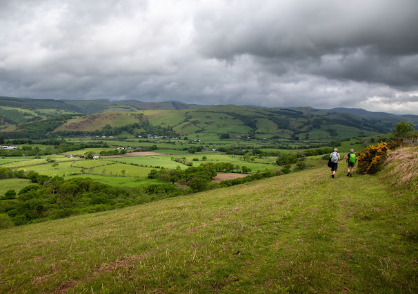
The route commences from Abbey cwmhir, where an abbey was founded in 1143. It was sacked by Glyndwr in 1401 as he suspected the monks sided with Henry IV. There is a long but not steep ascent out of the village, starting by an old petrol pump. From here on, Glyndwr’s Way is more direct, rather then the meandering route on first two days. Via a plantation, a road and open fields, we ascend to Upper Esgair Hill, where we chat to a farmer who has lived in the same farm for 72 years, then descend to the hamlet of Bwlch-y-Sarnau. Sadly, Glyndwr’s cafe. - a help yourself service run by the local church - is closed due to Covid. Completely ridiculous reason, more likely they can find no-one to restart the cafe.
 |
| A favourite image of the walk |
A descent and ascent through woodland (of which there is more today than on previous days) and fields. The scenery is fantastic, more agricultural (sheep and dairy farming) than first two days. Temperatures are lower with a welcome breeze. The going is easy. The 103 turbines of Llandinam wind farm are in view for much of the day; there is a plan to replace the 103 with 34 larger turbines.

We lunch by a brook and cool our feet therein before negotiating a zigzag stretch of the Trail. The waymarking is excellent, you could almost walk the Trail without any navigational aid.
After crossing more fields, we exit onto a road and walk tarmac apart from a short stretch through woodland all the way to Llanidloes, leaving the Trail at the black and white Market Hall, dating form 17th century.
Another great day, perhaps lacking the variety of days 1&2, but this is being picky really. 7/10.
A very different weather forecast is in prospect for today: showery with possibilities of thunderstorms later in the day. Consequently, less water is needed, but cagoules (I take two with aim of wearing one over the other if it rains hard) definitely are.
We set off at 0845 after breakfast at the uninspiring Mount Inn (the couple we have met on past 3 days said their meal last night was terrible and the accommodation is basic). Mike is being dropped at about the halfway point; we may meet him later.
The route passes along China Street and Long Bridge Street, then crosses the River Severn. Shortly after turning left just after the bridge, the Trail leaves the town with a steady ascent through woodland and past St Idloes golf course.
The next few miles are mostly through fields to Bidffald, where there is a short stretch on then parallel to B4518. I think it is on this road that I had my Eureka moment that Glyndwr’s Way is a must walk when returning home after a few days walking the Wales Coast Path.
We stop for break just before descending to the Lyn Clywedog Reservoir Dam. In front of the dam is an old lead mine: Bryn-y-tail. Ascending again, we stop again for coffee at the reservoir cafe then continue along the south of the reservoir, firstly with it in view (stopping for lunch on the way), then behind Banc y Groes, a hill that defines the south western corner of the reservoir.
 |
| Lyn Clywedog Reservoir |
A short forested stretch follows, then road and field to Staylittle. We organise our pickup with Plas Esgair on the way.
A steep ascent from Staylittle ends in a field with no waymarkers. We find the bridleway we need to Dylife just as the heavens open. I don’t even have time to double up on cagoules before a very heavy shower ensues. Fortunately it is only about a kilometre to the junction of the path where we descend to Dylife and await the owner of Plas Esgair to arrive and take us to his remote house and B&B near Llanbrynmair. Regrettably, the Star Inn at Dylife no longer provides accommodation.
 |
| Sign of the forthcoming rain |
The walking is similar to yesterday. Someone in Mount Inn suggested it is more mountainous than yesterday with views as far as Cardigan Bay, Snowdonia, Cader Idris, and Brecon Beacons. We saw none of that; perhaps he meant further on, where we start tomorrow.
The reservoir adds a dimension to the day, which is well worth 8/10.
Plas Esgair is an unusual place: full of antiques in a house that the owners bought in 2018 to do up. It is work in progress and a very interesting location to stay.

Day 5 Dylife to Machynlleth 14.5 miles
After breakfast at Plas Esgair, Robin (co-owner) drives us to start point near Star Inn. A short ascent returns us to the slopes of Penycochren. The weather is disappointing today as we walk a mountainous section in low cloud and mist. The views promised by the guy in Mount Inn are completely obscured. But at least it is not raining (albeit with odd periods of drizzle) and the going through the moorland is easy. We are four again, albeit regularly meeting with a woman who was also staying at Plas Esgair.
 |
| Moorland as the Trail approaches highest point |
The path continues past the pool of Glaslyn, which appears to be a cwm, albeit not at the head of a valley. the classic location for cwms. A further ascent to the southern slopes of Foel Fadian leads to the highest point on the Trail, at 550m.
 |
| Low cloud obstructs what would be fine views |
The path for the descent is very well made: shards of shale prevent a muddy alternative. We stop for a break at 8k as the path heads into woodland.
After the spectacular mountainous stretch, the Trail becomes more similar to previous days: farmland interspersed with road and woodland sections. At Cwmydwrgi there are some spectacular views of Cefn Modfedd and surrounding peaks - a fine example of why you should look regularly behind you.
The final third of the walk is mostly through low level woodland and scrub, exiting onto the slopes of Bryn-glas with views over Machynlleth. The path exits onto a road and is congruent with the Wales Coast Path (walked in 2017) for a mile into the town. It feels a little like meeting a long lost friend!
We end in Machynlleth; take the statutory photograph in front of a monument and head for Mach's Taxis where we collect our bags just as Peter's Taxis arrives to transport us back to Knighton where the cars have been parked at the Offa's Dyke Centre.
 |
| Half the Trail completed |
This is a great day; arguably the best so far. 9/10 as unfortunately unable to see enough in the mist to justify a maximum.

Comments
Post a Comment