Days 6-10 16-20 Machynlleth to Welshpool May 2022
All images for this section are on:
Glyndwr's Way Days 6-10 | Flickr
Day 6 Machynlleth to Llanbrynmair 16 miles
We return to complete the Trail: Jackie, Dom, Steve and me. Sadly, Mike is unable to make it as he has a recurrence of the dizziness, loss of balance, and weakness that he suffered on day 1 last September. I am especially disappointed as Mike has been an almost constant companion on the Trails I have walked, starting all the way back to 1 December 2012 when we walked from Minehead to Porlock Weir, day 1 of the South West Coast Path. But we have booked this week, and must take the opportunity to continue and hopefully complete another National Trail.
Having had breakfast at Maenllwyd Guesthouse and photo before we start, we set off eastwards. The Trial follows familiar territory for about a mile: a road with a golf course either side that doubles up as a sheep field. Mike and I walked this when staying at a B&B when walking the Wales Coast Path.
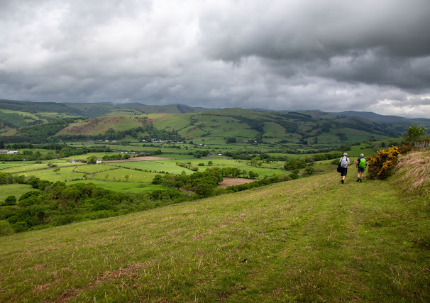
Passing the B&B, the route leaves the road and ascends a hill before descending to Penegoes for the first of today’s two stretches along thd A470. The route basically follows the A road to Llanbrynmair, firstly on the south side, then the north side but generally well out of sight of the road. It is a winding, almost tortuous route.
 |
| Rolling hills |
Leaving the A470, there is a steep ascent, then a walk around Bryn Wg before a descent to Abercegir. The going is good; weather as forecast: dull but mainly fair with just the hint of rain.
 |
| Abercegir: one of the pretty villages en route |
As we ascend to Rhos y Silio and Cefn Coch, there is some rain necessitating. a hasty change into rain gear but the rain lasts only for a short period. There are many sheep in all parts of the walk; it is end of lambing season. We are struck by the remoteness .of the countryside: scarce farmland surrounded by the Cambrian mountains, it is quite beautiful and more scenic than I had anticipated.
We lunch before descending to Cemmaes where the second stretch along the A470 occurs. From there, the Trail continues alongside the Afon Leon before a long ascent - the toughest of the day - to Cerrig y Tan. This is a lovely part of the Trail: quite remote with beautiful views in all directions,
 |
Shortly after, I ring the Plas Esgair to say we shall be arriving soon in Llanbrynmair, only for the weather to take a turn for the worst and we endure a 10 minute hailstorm on the sharp descent.
we reach the road near the farm at Brynaere and shortly after meet our lift to Plas Esgair.
This is a wonderful walk, mainly through fields and access land. The going is good, the Trail well signposted, and we are lucky that the rain holds off until near the end.

Day 7 Pen Pumlumon Ascent 11 miles
This is a first for me: an interruption to the natural flow of Trail walking by including a day that is off Trail. Pen Pumlumon is the highest peak in the Cambrian mountains and the source of the River Severn. Cicerone guide suggests it is a good extra day to add to the itinerary - it makes another 5 day walking trip.
I doubt we shall be this way again so it seems almost too good an opportunity to miss. It won’t count towards the mileage of the Trail but, as it is part of our walk, include it here.
The Cicerone guide suggests a ‘there and back again’ route but we have asked our hosts at Plas Esgair to drop us at a parking place on the A44 between Llangurig and Aberystwyth so we can ascend the mountain and then return via the suggested route.
We start at 1015; take a path that joins soon after with Cambrian Way. Going is good, weather fine but cloudy. These good conditions mean we are at the summit by 1130 and looking to finish comfortably by 1500.
 |
| summit of Pen Pumlumon Fawr |
The route to Dilyfe is further and more difficult underfoot and navigationally. To start with we follow a fence along an informal path that has clearly been used (even by a mountain bike) before. After 90 minutes just off route we come across the official source of the River Severn with a marker post.stop for photos and lunch.
 |
| Source of the River Severn |
There is still a fair way to go. We can either follow the Cambrian Trail until it joins Glyndwr’s Way or take the remaining route suggested by Cicerone: a direct route across access land with no path.
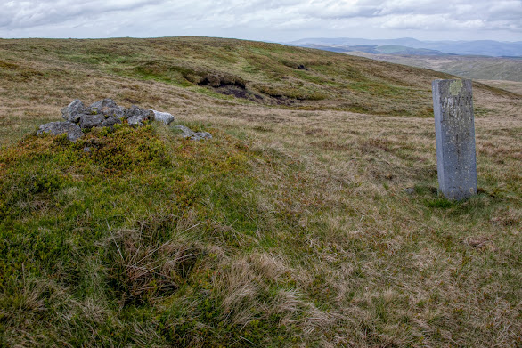 |
| Boundary marker between Ceredigion and Powys |
We decide on latter as it is more direct but the going steadily becomes more difficult: tussocky, boggy and poorly defined. In hindsight, the longer route would have been quicker. We shall be at Dylife long after our 1500 pickup time.
The worst part is just before we rejoin Glyndwr’s Way: a steep descent through forest that has been felled and across a stream. We make it but I certainly would not wish to be doing this in reverse.
At 1610, we arrive where our host is parked to return us to Plas Esagair but he drives off without noticing us just as we are just a few metres from the car! We must wait 30 minutes for him to get home, find out we arrived just as he drove off, and return. Luckily, there was sufficient mobile signal for me to get through to his partner at Plas Esgair to say what had happened.
This is a good walk to the highest peak between Snowdonia and Brecon Beacons. I would not recommend the direct route personally, nor doing any sort of ‘there and back again’ to Dylife; the going is too difficult and slow. Pleased to have completed but not a walk I would repeat.

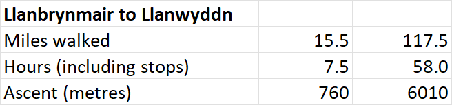
Day 8 Llanbrynmair to Llanwddyn 18 miles
This is the longest day of the Trail. The weather forecast is good - fine all day with the possibility of clear skies - so we have a good opportunity to complete in reasonable time. Cicerone reckons 8 hours; add some time for breaks, missing the route, checking navigation etc, and we should finish around 1800 based on our start time of 0915
We are dropped at the start point for today and almost immediately go wrong. Four of us mange somehow to miss a marker post and consequently head off I wrong direction. I notice an absence of waymarkers at a fence; a check on phones shows us we have gone wrong. Fortunately the error is minor - adding about 500m only - and we continue parallel to railway line before negotiating the steepest ascent of the day to Bwlch Glyn. It is long rather than steep but by finish have already completed 25% of the day’s total ascent.

We enter what was forested land at Cors Forchog, but is now a wasteland of cut tree stumps and associated dead vegetation. After a short break, we enter the forest for real, exiting on remote heathland where we encounter for the first time today a human being: a birdwatcher seeking images of goshawks in particular.
 |
| Sheep abound at this time of year in particular |
Taking a track, we descend to a road by the Nant river. It is a road form nowhere to nowhere and we see only one lorry while walking 2.5k to Dolwen. I need to stop because of right foot hurting. I think it is incipient blister but later see that the problem is a bruise caused by pressure from boot yesterday.
We have to ask the farmer here to clear the path through her farmyard before ascending Pen Coed and walking along a well waymarked route. My foot is really painful, such that I have doubts whether I shall be able to continue tomorrow. But as we descend and walk through yet more fields of sheep, it eases.
Eventually we reach Llangadfan for a welcome coffee and cake at a cafe on the A458. An earlier signpost says this is 10.25 miles from Llanbrynmair but our watches and phones as well as our instinct (we arrive at 1430, over 5 hours after starting) reckon we have walked 12 miles. We satisfy ourselves it is about 10-11k (6-7 miles) to finish, so the earlier waymarker must have been wrong.
The remaining route is due north to Llanwddyn. The Trail follows a road and fields of sheep (we see about 10,000 sheep today for every human seen) before entering Dyfnant forest. The remaining 8k is through the forest and along some remote and hardly used roads to Ddol-Cownwy. A sharp ascent through the forest brings us to a view of Lake Vyrnwy and the dam, accessed by a steep descent.
 |
| Descent to Lake Vyrnwy |
We stay at Dam View (the clue is in the name), a modern B&B with good facilities and enthusiastic hosts. We take opportunity to cross dam and walk other side before departing on following day.
This is another fine day walking through remote farmland full of sheep and lambs at this time of year, and monoculture forests, some of which have been felled, leaving a desolate looking landscape. We see only a few people all day.
Day 9 Llanwddyn to Meifod 15 miles
After breakfast at the excellent Dam View, we take opportunity to walk along the dam wall, take photos and stroll through the Sculpture Park before setting off on penultimate leg of the Trail.
 |
| The valley from Lake Vyrnwy Dam |
The first mile is alongside the River Vyrnwy; much of today’s route is near or alongside the same river. The route also. coincides along various stretches with the Cross Britain Way.
Ascending, we enter the Yr Allt Boeth Forest; a series of forestry track, including a stepped climb, ends with a descent to Pont Llogel. Here we meet, and follow alongside River Vyrnwy with, the Ann Griffiths Walk. Griffiths was made famous by writing many hymns and poetry in Welsh language in late 18th century. She lived in the area, dying aged 29 after childbirth.

The sun comes out and we have blue skies for the first time this week. The Trail leaves the river, ascending through fields of sheep and lambs. At one point, Steve and I recombine to release a lamb whose head became stuck in the wire fence. As on other days, we see no-one; it is almost as if we own for a few moments the lovely countryside. Our lunch stop affords views over the hills for several miles around. As we progress eastwards the mountains become hills; the scenery is more rounded.
 |
| Releasing a sheep - I lifted rear legs |
We descend to Dolanog; after walking along a road, there is another delightful stretch along the River Vyrnwy. It is perfect weather for the delightful riverside walk, the first we have done on the Way. Thei section is really beautiful, a highlight of the Trail.
The riverside walk ends at Pontrobert. We rest awhile as temperature has increased then proceed along minor roads before walking through yet more fields of sheep and lambs. For every human we have seen, must have seen 10,000 sheep and lambs. At one point we witness a farmer, his helpers, and sheepdogs round up a few sheep that have passed through a fence.
This wonderful day ends with a walk around the edge of woodland and before descending to Meifod and a well earned pint at the pub.
This is a fantastic walk, up there with the best I have done on Trails. The weather of course helped, but there is much variety in the scenery; the going is good; and no-one to share it with.

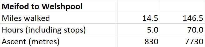
Day 10 Meifod to Welshpool 11 miles
This is the shortest day of the Trail: a welcome relative break as we head home afterwards, and the weather forecast later is unpromising.
The owner of Traig y Fan, our final and very good B&B drops us at the car park in Meifod 1.5 miles away. The route commences by crossing the River Meifod and following a minor road before leaving for a steep ascent of Broniarth Hill. After 1k along a minor road, the Trail heads cross-country; the countryside is lower level east of the Cambrian Mountains but sheep still number humans at least 10,000-1; it is just past lambing season, we are told by one farmer, when sheep and their young first graze in the same pasture.
The rain that has been threatening and evident in the surrounding area engulfs us, then passes quickly, then returns. It is wet gear on, then off, then on again. I wear over trousers for first time for a long time.
 |
| iPhone image on Welshpool golf course |
This winding route heads southwards, ending with a steep ascent to the golf course on appropriately named Y Golfa. From there is it is a gradual descent eastwards to Welshpool, and what seems a long walk through the town, the largest on the route.
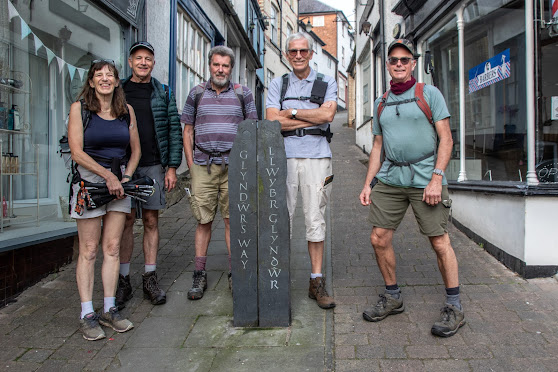
We have time for the statutory photos at the marker post next to the canal before heading our separate ways. It was a good and quite challenging day with two steep ascents.
 |
| End of the line at Welshpool |
Comments
Post a Comment